|
From the EH2R log book: 2003 Data for 2008 Data for 2007 Data for 2006 Data for 2005 Data for 2004 Data for 2001 and 2002 Back to current data |
||||||||||||||||||||||||||||||||||||||||||||||||||||
Dateline Resolute Bay 74 43 north 94 57 West |
||||||||||||||||||||||||||||||||||||||||||||||||||||
New generation sequences have exact times and or coordinates, meaning that bearings are extremely precise. There are 5 locations where the following pictures were taken. Three in Resolute Bay, 2 in Montreal. Montreal sequences are denoted, otherwise all other pictures are from Resolute Bay. Please note the records so far, lowest sunset ever filmed was in Resolute bay in 1987, lower than –4.4 degrees, 2nd place was in Resolute November 2002 at –3.3 degrees. Greatest number of Green flashes in one sunset observation was seen February 3 2003, several dozen were seen. To date no official Almanac nor sun tables explain nor acknowledge that many of the following events can exist. |
||||||||||||||||||||||||||||||||||||||||||||||||||||
Beginning 2003, many discoveries... |
||||||||||||||||||||||||||||||||||||||||||||||||||||
|
- Hill lines - Quadruple sun lines - Double green flashes - N.Z. effects not affected by clouds
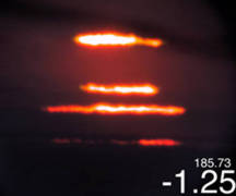
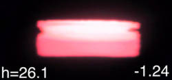
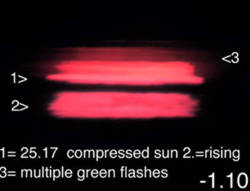
4th warmest January in Resolute Bay's weather records could have predicted a weak boost for the official end of the long Night. But February 3 had quite a show! Multiple green flashes were extremely bright, there were many sequences of multiple lines as a result of an inversion +0.073 C/m with top at 166 meters ASL. The picture above is one in a series of remarkable shots. Official sunrise was slated for February 5 at 1730 UTC. Analysing the data will take a while....
February 3 sequences show in particular 2 important discoveries. Confirming previous data page observations Novaya Zemlya effects need no clear air, they can be seen despite the presence of clouds. The boost was not impressive but multiple lines, up to 4 was a record of sorts. As the sun line skimmed the horizon, 2 layers of green flashes were constantly present above having various shapes, all the while a lower red flash apparently coming from sea ice appeared when the sun lines were free from low lying clouds.
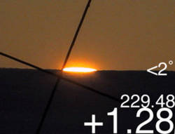
Hill sun lines appeared to distinguish themselves by their apparent smoothness and of course brightness and colour, clearly contrasting with horizon sun lines which are the product of which very strong refraction plays an important role. Refraction boost as with the left picture was not much different then with the Air Almanac, this table calculates a theoretical upper limb boost of +0.40 degrees while in this case it was greater than +0.50 degrees. A revelation was given in the zoomed shot (right) taken a few seconds later, multiple lines were found due to a strong filter, showing the complexity involved with multiple light paths trapped in ducts below or above the main inversion layer.
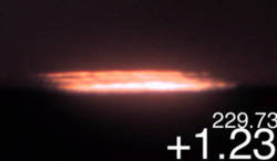
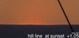
Sunrise over hill lands not showing any signs that there was an inversion above them. Notice the roundness of the upper limb.
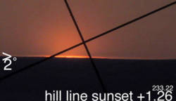
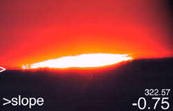
Sunset behind a hill hiding the frozen sea of Barrow Strait. Hill lines are truly elegant as with the left shot, sunlight is trapped within a shallow inversion, again interesting to compare with horizon sun lines, which do not appear very wide nor as shallow. The smoothness or horizontal aspect of the effect is another feature clearly not consistent with sun lines. The right picture was taken at sunset with a hill 2 degrees above the horizon, the upper limb boost was 0.75 degrees compared to the almanac's 0.5 degrees, this boost difference increases dramatically almost exponentially below a sun position of 1 degrees elevation. March 2003 -Huge Wegener Blank strip captured -Massive warming of the atmosphere made apparent by shorter sunset tardiness. - Differential refraction readings directly related to sunrise and sunset times. - The grail sun. 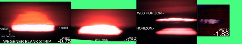 [WBS3Mr07] The German Dr Wegener theorized about an effect which has his name. The sequence of March 7 is a Wegener Blank Strip. Warm Katabatic winds changed surface temperatures from –40 degrees C to –10 C. This infrequent occurrence caused the trapping of a warm layer of air 2000 meters thick. On March 7, a cooling process occurred, surface temperatures dropped to –25 C, but the warm thick layer was still present, and this for quite some distance. This caused a blank strip, which made it possible to see mountain features more than 100 kilometers away. The extreme left picture shows a sun disk almost vanished on top of the apparent sun very much rectangular, the rectangular appeared mainly below the apparent horizon. The second picture immediately to the right shows the sun almost extinct while the rectangular becomes rounder. Third picture from the left had a flash within the center of the strip while the lower rectangular faded. Finally, typical to a blank strip is multiple lines merging or forming but eventually disappearing well above the horizon, in this case it was about 0.2 degrees above the apparent ice horizon. An important reference to study about blank strips is : “Sunset science. II. A useful diagram” by Dr Andrew T. Young and George W. Kattawar. 20 June 1998. Volume 37, No. 18. Journal of Applied Optics. In this Paper there are some basic explanations which help understand some of the pictures shown above.
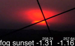
March 9 2003, Fog probably turned this sunset into a partial one. But the distant fog bank appeared weak. The lower left picture numbers are about horizontal diameters of the sun disk. This will help in breaking down sunsets or recognizing whether it is a true sun disk or a mirage of the sun disk (such as green or red flashes amongst others). The drop in disk diameter from the first picture to the last indicates a more or less normal Arctic sunset without sun line suggesting a very warm atmosphere.
March 10 demonstrated visually that there is a persistent inversion band which affected the sunset by adding extra features such as triple red flashes (extreme left) merging the setting rectangular sun disk (middle) , eventually everything merged into a line skimming the horizon (right). Sunset refraction boost was comparable to 2002 at about the same date. Stronger optical instruments are forcing a re-evaluation about sunset phases, there are many more than previously conceived. Visually the basics are still: 1: ellipsoid, 2: rectangular, 3: pre-line and finally the line. With telescope this changes a bit to 1: ellipsoid, 2:. Cut-off or flat bottom, 3: Multiple rectangulars, 4: multiple pre lines, 5: the line (usually alone) all while several (dozens) extra micro-duct generated green and red flashes are occurring.
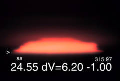
Compared to March 11 2001, the same day sunset boost is weaker by 0.3 degrees, but 2003 boost is slightly stronger than last year by 0.24 degrees. It is now becoming a familiar sight, the small islands to the west were seen upside down on top of themselves, the sunset went accordingly, there was a shallow blank strip, the setting sun disk got cutoff at the point where the upside down hill started, at about that moment the lower limb of the sun disk appeared to rise towards the cutoff point, eventually almost not touching the descending sun, the end product was a single sun line which skimmed the apparent horizon for a short while. The Upper Air profile giving this event had a shallow inversion of 0.04 C/m which continued at a step by step gradual weaker rate until 1692 meters.
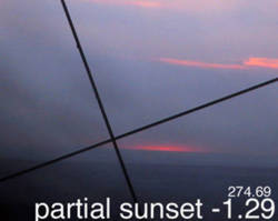
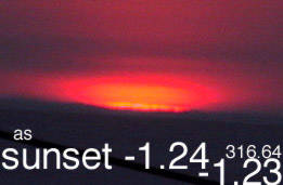
March 13 had a difficult sunset to analyze. It is therefore a partial sunset at a mere –1.39 degrees, suggesting warming. Upper air stratum had a weaker inversion than previous days.
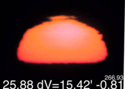
March 14 of 2003 had nothing similar to March 14 of 2002. Sunset happened at a paltry -1.45 degrees. Upper air profiles of late showed a remarkable warming trend throughout all heights of the atmosphere except for surface temperatures. Last year at the same day a near record –2.29 degrees sunset was filmed. Differential refraction shots taken the same days also showed remarkable inflation of the sun disk for 2003 , this is due to atmospheric warming as well. One method confirms the other, an exciting discovery. There is a direct relation between sunset tardiness and sun disk compression.
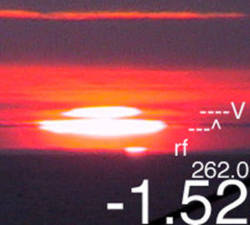
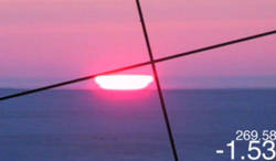
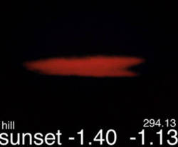
On March 16, the line was measured to be 0.87 minutes thick. Skimming lasted about 5 minutes, upper air profile was in fact warmer than March 14, a high pressure system lying directly west demonstrated that in situ measurements should be taken cautiously, the upper air profile was not representative of the air further West . What was significant was the clear capture of a red flash feature which remained at a constant elevation but affected the sun disk shape as it went through it. At one moment there was a rectangular feature seen first at the lower limb which progressed gradually to the upper limb. The same process continued affecting the line image at lower elevations. The line skimmed on top of the ice horizon while red flashes were mainly below the ice horizon as seen on the images above. March 16 sunset at –1.98 degrees is the lowest of this season.
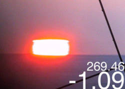
March 17 had a mild Wegener blank strip suggested by merged sun lines which disappeared in mid air as on extreme right picture. The grail sun (3rd from left ) authentic Sun was the fine line on top distinguishable by its brightness. Zoomed images of sun disk transformations provide important clues, however visual observation shows how different the two images differ (extreme left and 2nd from left). There was a vibrant huge rectangular sun spanning the entire height of the strip. Sunset at –1.71 occurred well above the ice horizon.
The upper air profile was amazingly warm, except near the surface, this might be due to the lack of snow on the ground which sublimated in warm winds. Sunset line lasted a short while under a weak vail of fog, weak enough to prevent telescope filter shots. The small boost at sunset (1.5 degrees) comes as a direct result of the warm profile, differential refraction numbers showed a sun disk much inflated at all elevations. Late March Early April - Great reduction in sunset tardiness - Observing inversion lines - Green flashes not as prominent as last year - Polar Stratospheric clouds as sky markers - Stratospheric warming and weak refraction boosts
March 20 was another warm day for the atmosphere, although there was some cooling in the troposphere. Clouds prevented a clear sunset observation. A thin sliver of clear air just above the horizon helped estimate the sunset to have happened –1.30 degrees. Differential refraction measurements again showed a refracted sun disk much inflated compared to last year.
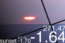
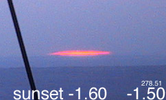
March 22 sunset had a line, no way as long as previous years, skimming lasted until –1.60 degrees, which is lame compared to previous years –2.3 degrees. A sure sign of warmer times to come.
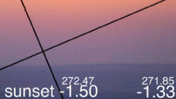
March 24, again similar weak sunset boost, the stratosphere was unusually warm, which again suggests an influence, not accepted by present notions. The light path in the stratosphere at –1.5 degrees goes well in excess of 300 kilometers, a great chunk of not so dense air should have unexpected effects on the overall boost, the tropospheric profile of this day is in fact slightly colder than a famous boost profile of –2.29 degrees. The difference is all in the Stratosphere, colder by a margin of –10 C from the Tropopause upwards. The lower near surface profile was identical with temperature profiles but slightly colder than with –2.29 sunset.
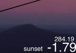
An important cooling occurred in the troposphere, this caused a brief come back of the line. –1.79 degrees sunset is still not strong. Again the troposphere was significantly colder and the Stratosphere was significantly warmer than with a –2.29 degrees sunset.
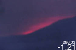
Tropospheric cooling maintained itself despite this weak sunset. The difference between March 25 and this day is a significant drop in height of the tropopause. Notice the inversion lines (thanks Andy) on the left picture, they closely mimic cloud profiles in fact they match in appearance so well that one might think that the sun has lots of clouds in front of it. That is not so, the jagged edges of the sun’s left and right limbs help a lot to distinguish this fascinating feature. The sun line was captured but briefly. Total refraction boost was weak as well.
The hill took care of exact sunset timing for a while, but these two pictures of March 28 have incredible significance thanks to the clouds. Again note from the left picture that it is difficult to distinguish inversion lines with the clouds. On the sunset shot to the right, clear distinctions can be seen. Winds flowing downhill act as an areo-dynamic tracer, they molded some clouds , immediately above ground, to conform with the flow. All while in the background, the clouds unaffected by the hill are clearly stratified. A dim sun line conformed with the flow as well. However, is it an inversion which affected this sun image? Or rather, like I prefer, a stream of air.
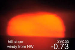
From the Northwards slope, again fascination. The Sun profile is certainly not mimicking the slope, a different telescope provided higher resolution, but no clear definition, visually, inversion lines were horizontal. Deformations were not following the profile unlike pictures of the Southward slope. An explanation may be winds coming towards the camera lens, a different flow of air. Sunset occurred on flat ground, again a weak –1.4 degrees boost.
Nearing the closing of 2003 season, April 16 sunset was a good example of a warm season, despite at times cold seasonal surface temperatures, the upper air was mostly warmer than last year everywhere. Refraction Horizon boosts were weak. It is not absolutely clear why. But one thing is certain, the Stratosphere was unusually warm all winter except for November 2002. Surface inversions were fluctuating in intensity wildly all winter, there seems to be no detectable consistent pattern with inversions. The line (at upper right) lasted but for a few minutes. There is a slight horizon slope affecting sunset times, as with previous year.
For the last time of the season, the line was seen, slanted up slope. The left picture shows amazing structure, especially at the extremes, three lines probably merged in the middle giving the illusion of a much bigger rectangular sun image. The sunset boost was again weak, but ice crystals exposed a great aureole of the line once curved around the prominent rock seen in the middle. The scattered reflections of the line are seen especially just above, the line is seen but faintly yellow just above the surface. Montreal Warm Troposphere Sequences
Montreal picture sequences, starting above, are dedicated to compare similar shots at same elevations. June 13 sunset showed some refraction strength resulting from some cold air about to vanish. A rare green flash, seen at left, appeared vivid green but the camera captured it red. The sunset had a small boost, noticeable only by comparing with further observations,. The sky was relatively clear from pollutants, although camera shots of sun disks below 10 degrees were reder than shots done in the Arctic. In Early June, Montreal weather was cool with a lot of rain, some differential refraction captures demonstrated relatively strong compressions until the weather warmed up at mid month.
The beginning of summer can be noticed by a weaker refraction boost, here comes warm air.
Contrast this Montreal June 18 warm air sunset to an Arctic sequence with cold polar air captures. The first thing which is greatly noticeable is the roundness of the sun's lower limb as it was about to touch the horizon, and further with time the roundness of the upper limb as it is about to disappear below the horizon. The generally accepted scientifc view would explain that inversions are responsible for much of the distortions near the horizon, but I have not seen, yet, any picture in such warm weather days which have had a significant sunset boost , perhaps -1.7 degree sunsets exists in Southern warmer climates, but they must be extremely rare. If so, cold dense air refraction boost contributions in cold are still not understood.
The next day from this sequence was abit coolish, again the sequence shows a greater sunset boost, the dip from the camera spot needs to be determined, but it is small or none existent. At any rate the sun set 0.13 degrees further North than the day before, suggesting indeed an important atmospheric contribution. [July 1 2003 addition follows> the dip has been measured and there are none, or if it exists it is extremely small. The camera location is from a hill and the horizon are the Laurentian mountains, the two sites cancel each other. 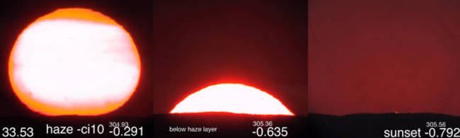 [3sjn22004625] The next few June days were warm and very humid, having a little heat wave with daily temperatures in excess of +30 C. It was made evident by the presence of haze, in this sequence the main haze layer wasjust above the ground. Meaning that at about .3 degrees above the horizon the haze layer was not so apparent. The layer made for some extraordinary effects, similar to inversion lines.  [3sjn25004659] In the middle of the heat wave about to cool down a little, haze dominated at all levels, forcing me not to use a telescope filter, haze or thin clouds dramatically reduced the brightness of the sun. As an inadvertent benifit you can see inversion lines quite well, this sequence was taken before several days of clouds, and was pretty much the last sequence taken during the mini heat wave with daily maximums above 30 degrees C. 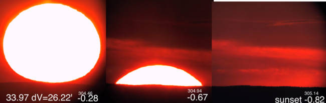 [3snjy01004700] A definit cooling of the atmosphere can be noticed compared to the preceding sequence, namely the sunset was higher and differential refraction shot (extreme left) shows a clear compression of the sun by a significant margin. The temperature outside was 24 C. July 1 weather was a nice cooler day, still warm at +25 C. July 1 004700 above sequence was taken in the evening of June 30. All times are GMT. There was also very little haze compared to a few days before, different air masses with many periods of rain showers explain this difference. Very few green flashes were noticed in June, a few were captured in early June at a colder air mass time. It now appears certain that weather forecasting can be done based on differential refraction readings and regular sunset observations.  [3sjy07004510]  [3sjy09004420] 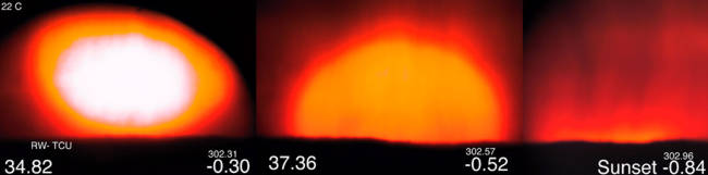 [3sjy14004144]  [3sjy18003848] Akhet sequences: One of the earliest known names for horizon is Akhet, ancient Egyptian for Horizon, the Hieroglyph looks exactly like the first pictures at extreme left. There is a famous name place called Akhetaten, place of the horizon sun, it was a temporary Capital of ancient Egypt created by Amenophis IV or the revolutionary Pharao Akhenaten, called heretic for introducing monotheism. Akhet shots are of the type when the lower limb of the sun touches the apparent horizon, this point can be measured by using astronomical elevation at the time of contact. In the case of these Montreal sequences, the horizon is the Laurentian plateau which has very little or no dip. Variations from one sunset to the next were noted to be directly related to temperature fluctuations, the warm days of July 7 and 9 had lower refraction boosts which can be detected earlier by the Akhet shot. The lower the Akhet elevation point, the later the sunset, this can be seen while comparing July 7 and 9 (warmer) and July 14 and 18 (colder). Other interesting features are the yet incomplete, due to clouds, differential refraction readings should prove to give the same forecast. July 14 had rain which proved quite interesting, the aureole or sun disk corona are identical as during snow showers. A small green flash can be seen on July 14 last picture. The sensitivity in sunset times are directly related to atmospheric temperatures, and there does not appear to be any detectable irregularities. 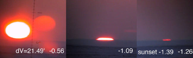 Resolute Bay April 2002[sa140313] Compare to a mild weather sequence in Resolute Bay with a dip of about 0.18 degrees, and note many differences between an Arctic Ahket sequence with a temperate one. The first thing that is apparent is the ellipsoid sun, but of course the sun line in Resolute skimmed the horizon much longer. Most cold sunsets in Resolute occured at about -1.7 degrees, double that of Montreal's, the sky colours are very much different as well, note the blue in Resolute, compared to the red twilights of Montreal.  [3sjy29002800] 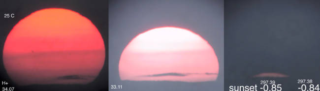 [3sa01002417]  [3sa13000427]  [3sa14000241]  [3sa15000447]  [3sa18235824]  [3sa19235648] Back in Resolute  [3sa28032017] Back in the Arctic since August 23, as of October 25, there was only one Akhet sequence, one sunset in 60 days. There has been a great deal of clouds this fall. Compare this August 28 sequence with Montreal Akhets, and you'll notice that it took a filter to film the horizon contact shot, unlike in Montreal where I had to remove the filter. Although August 28 shot in Resolute didn't have significant differences with Montreal boosts, once again proving that the Arctic atmosphere was unusually warm, as it turned out to be for all of September and October. Afterall clouds are a product of heat.  [3sn05192250] -1.31 sunset pales in comparison to november 2000 -1.7 degrees sunset at about the same time,. Since then photography has improved, but beginning of winter 2003 will be remembered as a time loaded with clouds which essentially reduced observations considerably. Few sun pictures have shown a noticeable inflation in differential refraction. Cloud prevalence and vertical decompressions suggest a warm winter to come. |